Posts Tagged ‘maps’

Getting around New Tou

by on Tuesday, February 18th, 2014

NTtransit-map-2014
The new intra-bayou ferry means it’s time for a new transit map. Here are our notes on the various routes:

Purple: Desire, a streetcar. She stops at the French Market, Laveau Square, and the police station, but feel free to hop on and off anywhere along the way. (Try not to get run over.)

Gold: This ferry takes you along the levee from the French Market dock to where the library is docked. It is mainly used by people with very sore feet.

Blue: This ferry connects the library dock to the main bayou dock and train station. If going from city to bayou, use this short ride to check that you have plenty of ammo.

Red: Mamou, once a streetcar, now repurposed for bayou rail travel. She connects the depot and the east end of the bayou. If you walk along the tracks, try not to be on the bridge at the same time Mamou wants to use it.

Green: This new ferry allows easy travel from the main bayou landmass to the islands—and incidentally makes for a pleasant tour, as long as you’re not worried about gators.

Silver: This marks the footpaths provided by the parish. The east-west one is in pretty good shape, but the north-south one will probably just slide off into the water any day now.

New ferry service links city and bayou

by on Thursday, January 31st, 2013

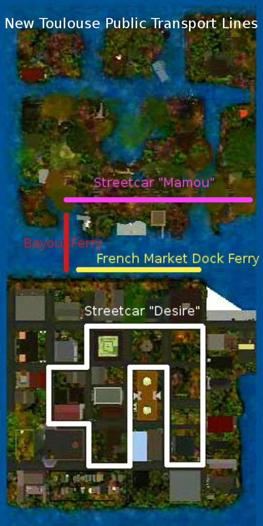
The French Market Dock ferry now runs from the French Market to the Bayou Ferry Landing. It is the latest public transportation route in New Toulouse and New Toulouse Bayou constructed by local government, bringing the total number of routes to four including ferries and trolleys.

“This will be the heart of the city,” said Pazzo Pestana, a city administrator in charge of transportation, pointing to the French Market Dock that, along with the new ferry, is part of a major renovation and revitalization program in New Toulouse. “This is going to be the landing point, so there will be a lot of info and things to interest people.”

“Right now,” said Pestana, “you can board the trolley at the eastern end of the line in New Toulouse Bayou, get off at the station, take the ferry across, change to the Market Dock ferry, then get off at the French Market, hop on the streetcar named Desire, and ride around New Toulouse.”

There are no restrictions on flying, but as Pestana puts it, “With the ferry, the hope is that people will slow down and enjoy the scenery.”

The map below shows public transportation provided by the city government.

New Toulouse Public Transport Routes

Habana Jazz is a resident of New Toulouse and calls his mother every week.