The new intra-bayou ferry means it’s time for a new transit map. Here are our notes on the various routes:
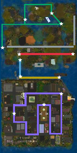
Purple: Desire, a streetcar. She stops at the French Market, Laveau Square, and the police station, but feel free to hop on and off anywhere along the way. (Try not to get run over.)
Gold: This ferry takes you along the levee from the French Market dock to where the library is docked. It is mainly used by people with very sore feet.
Blue: This ferry connects the library dock to the main bayou dock and train station. If going from city to bayou, use this short ride to check that you have plenty of ammo.
Red: Mamou, once a streetcar, now repurposed for bayou rail travel. She connects the depot and the east end of the bayou. If you walk along the tracks, try not to be on the bridge at the same time Mamou wants to use it.
Green: This new ferry allows easy travel from the main bayou landmass to the islands—and incidentally makes for a pleasant tour, as long as you’re not worried about gators.
Silver: This marks the footpaths provided by the parish. The east-west one is in pretty good shape, but the north-south one will probably just slide off into the water any day now.